
Travel Dispatch Three ~~~ Maps to Trustworthy Uncertainty
At the crisp start of a travel day, joyful adventure begins when having no idea where in the hell I am going. True, the map has been studied. The roads memorized. The plot line thought through. Travel though is not just the road less traveled but the path completely unknown and spectacular wonder in that spontaneity.
This summer 2025 I decided to bring a paper map for studying rather than relying on my electronic phone, often erroneously, telling me what to do. Being offline is a way of being into directness that I so value. Already having been in one place on the paper map, my intention is to review the next future location. And go there. In this way is a celebratory method to apply Melody Beattie’s work, a specific meditation called “Directness,” from her book The Language of Letting Go, Daily Meditations on Codependency.
She cuts to the direct chase and how else to describe optimal communicating, those being-direct results? “Direct people are a joy to be around,” Beattie confides. Thankfully, mapping their indirect is not a project. “When they do something for us, we don’t have to worry whether they’ll end up resenting us because direct people generally do things that please themselves.” My people-pleasing days are ever-goddess-grateful, at long last, over. Directly I often went to this road trip’s paper map to find my way because doing so pleases me greatly. Sometimes.
On an expansive travel day, I woke up to observe my coffee ritual. One fan I be of saying we have all the time in the world. For we do. An infinite is always the measure of being right here, right now. And leisure time made emotional space for a second cup and so I went to work brewing on a basic propane camping stove, through a paper filter snugly just right in a cone, another one-cup pour over brilliance.
Southern California sunshine shone brightly on this campsite inside Malibu Creek State Park. Downtown Los Angeles was 25 minutes away and I was glad for that distance. Rolling eventually into going forward in our Nissan Versa family car (a go-cart like compact), we had relaxed focus since noon is when we left. Plenty time to drive a few hours to Idyllwild Campground located along the San Jacinto Mountain range. Or so I thought without consulting the paper map during my coffee time.
One summer challenge had been for the teenager Darien to learn how to read a paper map. This travel day I simply asked, “Which road is the path?” The car was at a standstill. Hesitate he did and so we decided to go with yesterday’s familiar. Returning through the mountains and right directly to Pacific Coast Highway, again, same direction. I was so determined to not rely on my phone’s map. I wished to see if traveling based on just the paper map was even possible especially if I wasn’t the one decoding, a way to learn through listening.
Driving along the Pacific Ocean waterfront I saw once more the severe devastation to cliffside homes in Malibu, the mansions that had dwelled there. Bizarre skeletal carcasses remain, charred steel frames for a few homes and most were simply cindered to the cement foundation. More than a few had cars sitting idly in driveways, entirely burned. I thought I saw several Maserati masterpieces, formerly—and now a literal pile of dark grey ash softly shaped like a car.
Not far away, the day before, I had explored the Santa Monica Pier. And soon here she is on her pier legs strongly planted in the ocean. What is twirling are a summer whiplash of brightly colored foods: cotton candy, ice cream cones, pretzels, corn on the cob, and French fries. Hundreds of tourists from all walks of life happily held their paid-for food foraging. Crowds sauntered through the tchotchke stores, the ones heaping t-shirts, hats, coffee mugs, banners, shot glasses and pendant flags into preciously piled takeaways from the moment.

American french fries at the Santa Monica Pier.
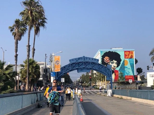
Tourists begin to explore the Santa Monica Pier.
Even as a fan of spontaneity and being pleased when a map’s uncertainty is in the works, might I have gone too far? I had no idea where I was after Santa Monica Pier. Refusing to activate the phone gps and having not consulted the paper map, I was lost. And Los Angeles is not an optimal, easygoing village to terrain leisurely. East is where the San Jacinto Mountain range is; let’s go that direction I cheered myself on. Arriving to Freeway 10 East, the road trip adventure propelled forward. The teenager Darien had gone rogue silent and studying his phone, random social media, like a tarot card reader, did he hope to divine in the screen a strategic road trip direction? I wasn’t quite so hopeful.
Yet directly pleased I was that at 1 p.m. driving on 10 East, the traffic was moving forward 55 mph or even faster. I called on courage to include an errand. Leaving Monterey, California a week earlier the Home Depot purchases were to fortify during difficult weather: tarp, bungee cords, a few metal poles and these could build an impromptu sheltered space. Yet so far, each travel day had brought reliable sunshine, a trustworthy meteorology. Return the items I could to lighten the car’s driving weight for better gas mileage. But caught I was while speeding along. Sourcing a Home Depot required I activate my phone. Giving in to the modern moment, what I saw on the screen were several Home Depot stores in proximity. I chose one and then I blithely dropped into East Los Angeles.
The energy I flipped into was humble. My upset from the morning map fiasco had gone—in the one hour since. Beattie reminds that with people who are direct, “we don’t have to worry if they’re angry because they deal openly with their anger, and resolve it quickly.” These summer travels I constantly worked with myself to resolve anger, swiftly. Grateful I have tools to go there. Soon another kind of anger left me teary eyed.
Traveling distance from Malibu had been just 30 miles and yet severe economics divided the disparate worlds. In Malibu, access to financial wealth visibly shows in every automobile, mansion, shopping center and demographic of name brand-clothed white folks. In East Los Angeles, neighborhoods are valiant for their people in visibly spirited community. Inside the Home Depot I walked into, once there a young Latina woman facilitated a swift business help (returning $125 of credit) and I was grateful. In the parking lot, two elderly Latino abuelos were going entrepreneurial and selling watermelon. Exiting the Home Depot parking lot, I drove a few blocks away and purchased lunch at In N Out burger. Most customers were people of color appearing Hispanic. The volume of many Spanish speakers had an ease and clarity that enriched the customer space.
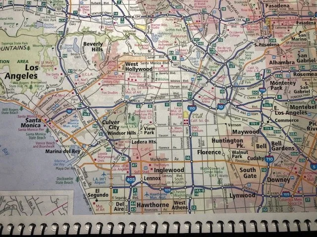
Going from Santa Monica Pier to East Los Angeles on 10 East.
Driving these East Los Angeles streets was a scratchy-heart experience though. You know the kind of moments where you would nearly give anything for a social-justice magic wand to wave away decrepit factories massively still at work, environmental pollution based on racism, and making a living that is barely livable. And one block over in a well-kept yard (now cementing over what had been soil), with a few leashed dogs to keep guard, someone planted a brightly blooming orange-yellow chrysanthemum in a pot with a Home Depot sticker still there. Humans always seek beauty. That’s the scratchy-heart time when I see these efforts and cheer on the valiance while dropping a few tears, not the blithely dropping into East Los Angeles I had seen on my phone’s electronic map.
Another startling contrast between Malibu and East Los Angeles is America’s militaristic force. Malibu had employed a long line of police cars to protect mansions after home owners fled the fire-destroyed scene. In East Los Angeles the US federal government had employed armed militia to arbitrarily remove Americans from local neighborhoods there. Indigenous Latinos living here posted a sign pledging retaliatory aggression if military force continued. I found the sign inspiring. One use of police was to protect and the other was police violence to assault.
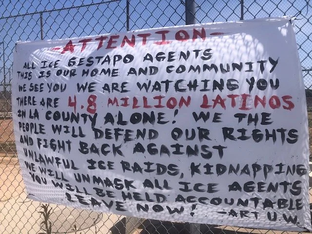
An inspiring sign posted for all to see on a Huntington Park Senior High School fence.
The travel day’s interior road map kept showing up surprises, often challenging ones to accept. For one, when the Nissan Versa was at a standstill at noon at the Malibu Canyon State Park campsite an option to circumnavigate downtown LA was so simply there. Turn the opposite direction, take freeway 101 to 210 East and make a beeline for San Jacinto Mountain range.
But this was not to be the path. Instead, I was seeing burnt Malibu mansions, partying Santa Monica pier, and politically inspiring signage paired with emotional-to-see environmental racism in East Los Angeles. These moments of summer traveling were early on in the following road trip days. and taught me with directness that the paper map has minimal influence on where I am going. Cartographers like historians ultimately decide what complexity goes on the map or in the book—and what does not.
Nicolas Carr writes in What the Internet Is Doing to Our Brains, the Shallows that “maps came to be used not only to represent vast regions of the earth or heavens in minute detail, but to express ideas—a plan of battle, an analysis of the spread of an epidemic, a forecast of population.” The map I had been staring at intensively while sitting at my desk in Hawaii and since the road trip began omitted complexity and made sense given the purpose. Rand McNally promises that this is “America’s #1 Road Atlas.”
But an emphasis on state parks might have funded the publication. The influence on my road tripping was that I also over emphasized finding state parks (many be quite expensive, too). Carr concludes accurately that “the more frequently and intensively people used maps, the more their minds came to understand reality in the maps’ terms.” Traveling though is going there on your own terms. When maps have biases (and many I discovered sure did), the direction is on me to discover through intuition where I am meant to truthfully go learning-wise. And that is the spectacular wonderful of spontaneity in any travel day: being so direct in my intentions.
For example, later this same day after being stuck in 10 East traffic several hours, a consequence linked to my spontaneous Home Depot errand, I began ascending a 9,000 foot mountain called San Jacinto and drove to the top. Because my phone gps told me so. Realizing my Idyllwild campground was in the valley, in reality, I physically threw my phone—and the paper map—in the back seat. Maps be damned at the end of this one day!
Deeply intuitive is how a travel day starts to map over time. Scanning a paper map’s “reality” is a familiar event during morning coffee, sure. And I might go to the holy grail of a phone gps. But what I surrender entirely is that either of these map methods will be a definitive influence on how the day unfolds or that I myself will make this or that happen. Not going to happen. This is a healthy energy or directness for traveling. Beattie reminds us that “we don’t have to wonder if we can rely on them because direct people are trustworthy.” Traveling in this way pleases me and so I go there directly with a few unmapped encounters along the way.
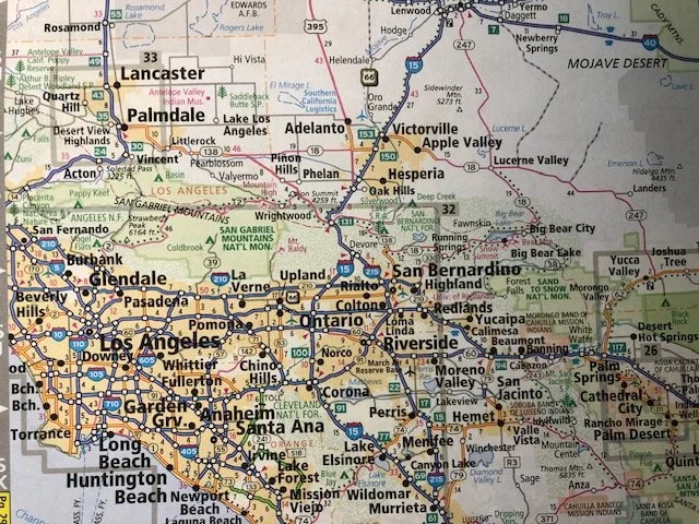
What could have been a two hour early morning commute to San Jacinto camping evolved as a full stretchey learning day. (Random author background: I was born in Hemet.)